
OFHS Family Migration Map
This map is intended to give an impression of how individual families have migrated between Oxfordshire parishes over the period 1538 to 1851. It is based on data from the OFHS Search Service baptism index.
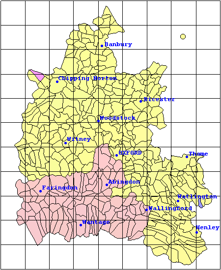
Just hover your mouse pointer over a parish to reveal its name, or click for more details.
Select a surname from the drop-down list below:
Scroll down for more details| IS YOUR FAVOURITE SURNAME NOT INCLUDED? |
|---|
| We have started by including some of the more frequently researched surnames but we are happy to add more. So if a name of particular interest to you is not included, just send an email to searches@ofhs.uk with the subject Migration Map Surname Request and for the cost of a single search fee (£2.00 UK pounds) we will add it to the map for you. |
| METHODOLOGY |
|---|
|
It is important to remember that the map can only give an indication of the number of people in a parish in any given year. There is insufficient data available to provide an exact figure. The data here is derived from recorded baptisms taken from parish registers. A typical family in a parish might baptise children every two years over a period of perhaps 10 years. There will then be a gap of 10-20 years with no baptisms until the first generation of children have grown up and started families of their own. With a pattern like this, simply displaying the baptism numbers for a single year would give a very disjointed picture of the family. We therefore display for any year, the number of baptisms in that year, together with a linearly weighted average of the numbers in the 9 years before and after the displayed year. Visually this gives a more accurate impression of the family presence. The scaling used to indicate the presence of a family represents the mean number of baptisms per year in the parish. This is depicted on the map by the colour shown for the parish, which follows a smooth progression from white, through yellow, orange, red and brown, to black, the latter corresponding to a mean rate of one baptism per year. The exception to this smooth progression is the transition from a zero presence (green) to the first appearance of a baptism for the chosen surname (white), where the strong colour change makes it easy to see the point at which the first family member appears in the parish. At first sight it might be assumed that one baptism per year represents a rather small presence of the family in a parish but this is not the case. By 1800, life expectancy at birth was around 40, so a sustained rate of one baptism per year typically corresponds to around 40 individuals present in the parish at any one time and represents more than five individual households. Note that because the data for this map is derived from the OFHS Search Service baptism index, no data will be shown for the small number of parishes that are not yet included in this index (approximately 3% at the time of writing). You can see which these are from the Parish Register Coverage Map on the main Search Service section of this web site. It is usually possible to infer a presence in these few parishes from the levels in adjoining parishes. |